Travel
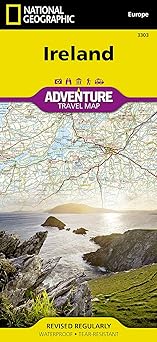
Ireland Map (National Geographic Adventure Map, 3303)
by National Geographic Maps
Published
January 1, 2019
Pages
2 pages
Language
English
Publisher
Natl Geographic Society Maps
Available Formats & Prices
View on AmazonAudio CD
$12.63
About This Book
• Waterproof • Tear-Resistant • Travel Map Explore the storied "Emerald Isle" with National Geographic's Ireland Adventure Map. Designed to meet the needs of adventure travelers with its detailed, accurate information, this map includes the location of cities and towns with a user-friendly index and a clearly marked road network complete with distances and designations for roads/highways, plus secondary routes for those seeking to explore off the beaten path. Specialty content such as hundreds of diverse and unique recreational, ecological, cultural, and historical destinations make Adventure Maps the perfect companion to a guidebook.
The Ireland Adventure Map covers the entire island including the Republic of Ireland and British-ruled Northern Ireland in one easy-to-use map. The north side of the map details from the northernmost tip of the island at Malin Head south to Dublin and Galway, including Belfast, Dundalk, Londonderry, and Sligo. The south side overlaps the northern side of the map at Galway on the west and Dublin on east, covering the remainder of the country including the cities of Limerick, Tralee, Cork, and Waterford.
Ireland's lush green landscape is a result of its temperate, oceanic climate. The island's geography is mostly comprised of a central plain surrounded by relatively low-lying mountains. Coastal regions vary from sandy beaches to towering cliffs that rise hundreds of feet above the pounding surf.
Castles, churches, abbeys, monasteries, and Neolithic sites abound, offering travelers a remarkable variety of opportunities to explore Ireland's rich and ancient cultural history. Every Adventure Map is printed on durable synthetic paper, making them waterproof, tear-resistant and tough — capable of withstanding the rigors of international travel. Map Scale = 1:385,000 Sheet Size = 37.75" x 25.5" Folded Size = 4.25" x 9.25"
Introduction
Embark on an exploration of Ireland like never before with the National Geographic Adventure Map 3303. This expertly crafted map is the quintessential travel companion for both seasoned adventurers and inquisitive newcomers. Designed to reveal an array of stunning landscapes, cultural sites, and intricate travel networks, this map ensures your journey across the Emerald Isle is both enriching and unforgettable.
Key Takeaways
Discover Ireland’s diverse landscapes and hidden gems effortlessly thanks to detailed cartography. Plan adventures with confidence using clearly marked hiking paths and tourist spots. Navigate the country with ease through comprehensive travel route information and terrain details.
Detailed Description
The National Geographic Adventure Map of Ireland serves as your window to the land of myth and beauty offering an unparalleled glimpse of its striking geography and rich heritage. Every fold of this map uncovers a new facet of the Irish landscape from towering cliffs to serene lakes and bustling cities. Ireland's allure lies in its sprawling countryside and historic nooks.
This map beautifully captures that essence with high-quality illustrations that highlight important landmarks and untouched natural beauty. With clear boundaries and topographical nuances it's easy for travelers to navigate between iconic locations and hidden treasures. Whether you're embarking on a solo backpacking trip or a guided tour this map ensures your journey is seamless and adventurous.
With detailed markers for areas of interest it helps in discovering local communities historical sites and natural wonders making each journey personable and meaningful. Designed with input from travel experts and cartographers this map emphasizes accuracy and accessibility. The essential information presented allows explorers to immerse themselves into Irish culture ensuring an unforgettable experience that goes beyond the traditional guidebook narratives.
More than just a tool for navigation the National Geographic Adventure Map of Ireland is an invitation to engage wholly with the landscapes and stories that define this enchanting land. With each journey it promises new discoveries encouraging explorers to delve deeper into what makes Ireland so unique.
Standout Features
The map stands out for its rigorous attention to detail, offering intricate topographical designs that highlight Ireland's varied terrain with unmatched clarity. With its focus on both popular and off-the-beaten-path destinations, the map caters to diverse interests ensuring no experience in Ireland is beyond reach. The collaborative expertise of cartographers and travel specialists ensures that every aspect of the map serves to enhance your travel experience, making it an indispensable companion for Irish adventures.
Book Details
1566955351
978-1566955355
9.25 x 0.16 x 4.25 inches
3.2 ounces
Specifications
Rating
Based on 975 ratings
Create Your Own Books Now
Turn your ideas into reality with our powerful book creation tools. From notebooks to novels, we've got everything you need to publish your masterpiece.
Low-Content Maker
Design journals, planners, and notebooks
FreePuzzle & Activity Maker
Create engaging puzzle and activity books
ProColoring Book Maker
Generate unique coloring pages from images
ProBook Writing Tool
Write your manuscript with our AI assistant
FreeCover Designer
Create professional book covers in minutes
Free+ProA+ Content Designer
Enhance your Amazon sales page visually
Free+ProCustomer Reviews
Great map!
What I needed for my trip
This map is essential
We just got back from our visit to Ireland and I felt compelled to write a review for anyone considering buying this map. I can easily say I relied on this map more than anything else and am so glad I made the last minute decision to purchase it. I downloaded google maps to use offline and got a rental with a gps unit but both of them failed me on more than one occasion. I ended up solely using this map and road signs to navigate our way through Ireland. We basically did a tour of the south - Cork, Killarney, Ring of Kerry, Valentia Island, Slea Head Drive, Limerick, Cliffs, Galway, Connemara Natl Park, and Dublin all using this map. We took many back roads (only hitting one toll road as we approached Dublin) as we liked the more “scenic route” and had no trouble at all. The map also clearly marks many great places to stop and see along the way. It was easy to fold the map to the area we were traveling, was easy to mark, and it held up - it still looks brand new. I wasn’t so sure about this map after reading other reviews, but I would strongly recommend it to anyone considering it. It’s compact, easy to follow, and well worth the small amount of space it took up in my luggage. Technology is great but easily fallible. This map never let us down.
Great primary and back-up tool when driving in Ireland!
I purchased this erasable road map of Ireland during our planning stages. This map earned its keep as my wife relies on her iPhone way too much. When internet service was scant or non-existent the map filled a huge void in our rural travels. It's also a great way to check your electronic devices to assure you're traveling down the proper road. Don't leave the USA without it.
Good quality
I really like this map, we’re taking it on a trip to Ireland. It has a durable finish, and is very detailed.
Nice back up to our cell phone
We primarily used the map on our cell phone to get around Ireland in our rental car. But a paper map is always handy to get the "big picture."
Map
We both haven’t got to Ireland yet but we will use when we get there and probably is better than the GPS on the phone. We are from the old school and we both did get lost with directions how to get to our destinations by GPS on foot. So paper map is always a handy guide when the phone doesn’t get to exactly where you want to go.
Great Backup Plan
This was meant to be a backup plan in case the Google Maps app on my smartphone lost signal. I like how the material is durable and water resistant. It folds up well and can be tucked into a backpack. The colors are bright, text is crisp, and information seems accurate. The legend is helpful. I could do without the stock photography on it though. I’d rather that space contain additional information, like telephone numbers for various nation-wide resources or certain laws and reminders that tourists should keep in mind.
High Quality Material, Excellent Details, Useful Extra Detail for Some Cities
Very well made, wonderful detail, clearly shows various types of roads, major highway, regional road and local road. Very helpful identification of many notable and not so notable sites to visit. Very detailed indexing of towns. Only drawback I believe to this map is in order to see the full county you must look on the front and then backside of the map. If seeking to map out your trip you may need to keep flipping the map over. This is, in my opinion, an acceptable inconvenience given the details contained in the map.